Hurricane/Post-tropical Cyclone Sandy and all of her fury are firmly ensconced in the record books, and this storm will remain forever in the lexicon of Northeastern US weather lore (probably foremost ahead of the 1938 Long Island Express). This is certainly true from an ornithological perspective, with some avian effects from Sandy still apparent 11 days after landfall, with potential for effects lasting for several more weeks. In particular, the aftermath of Sandy’s passage included a substantial movement of out-of-season and out-of-range Neotropical migrants and a noticeable flight of at least one European vagrant, Northern Lapwing. For the coming 7-10 days, birders should be on the look out for the appearance of late Neotropical migrants and other European vagrants, particularly in advance and after the passage of the strong frontal boundary in the middle of next week.
The continued presence of these disparate groups in the Northeast (not to mention the Pelagic and Arctic deliveries from Sandy) may not be the first hurricane vagrants that come to mind when one thinks of storm birds. Below, we provide what we think is a reasonable explanation for why these birds appeared with Sandy’s landfall. Associating birds with air masses is nothing new, and presumably those reading BirdCast forecasts and posts are quite familiar with this thought process. For our purposes, there is an excellent website at the Air Resources Laboratory that can plot the trajectories of air parcels, and we will use it to try to make sense of the Neotropical migrants and Northern Lapwing occurrences.
Neotropical Passerines
The following suite of Neotropical migrants (mostly passerines) appeared in unusual numbers from 30 October on, with sightings (most recorded in eBird) north of their usual areas from New York to Maine and inland as far as Ontario: Yellow-billed Cuckoo (4+), Eastern Wood-Pewee (10-15), Red-eyed Vireo (8+), Tennessee Warbler (6+), Northern Parula (10+), Magnolia Warbler (3+), Black-throated Blue Warbler (4-8), American Redstart (3+), Bay-breasted Warbler (1), and Indigo Bunting (15-20). Most of these species are largely absent from the Northeast after 15 or 20 October in normal years, so their occurrence into the first week of November 2012 has been remarkable. Many of these migrants were first detected in the 1-3 days following Sandy’s landfall. Since most or all individuals of these species should be at least 1000 miles or more from this region in late October (if not nearly on a different continent), we suspect that a reasonable explanation related to the circulation of the hurricane. We believe that a number of birds departing from the Southeastern US were entrained into Sandy’s circulation, and subsequently deposited along a broad portion of the Northeast US coast as the storm made landfall.
Let’s first look at Neotropical migrant passerines taking off from Florida or Cuba depart on the night of 26 October: a light to moderate migration was underway, with heavier movement on the western Panhandle of Florida.
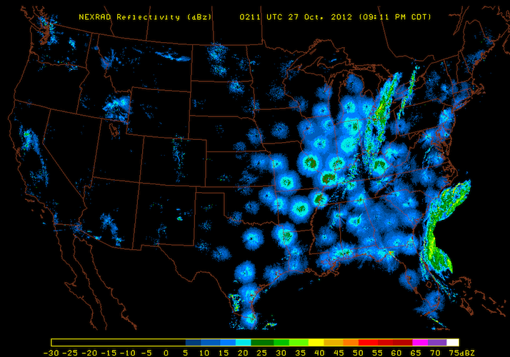
Widespread light to moderate bird migration (and other biological targets like bats and insects) occurred over much of the Southeastern US, including the Florida Peninsula and Florida Keys. Note also the heavy movements of birds occurring in the Mississippi River valley behind the cold front that would complement Sandy’s circulation. This image comes from Paul Hurtado’s radar composite website.
Let’s also consider the surface winds on take off that birds departing from Florida might encounter.
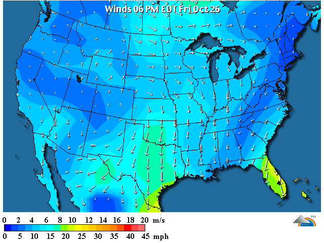
Surface winds on the Florida Peninsula are NE over much of the state, but winds over far southern Florida and Florida Keys are northwesterly. These winds are favorable for birds to migrate, and they also may carry birds right into position for Sandy entrainment. This graphic comes from Weather Underground.
This species group departing from Florida might include Eastern Wood-Pewee, Bay-breasted and Magnolia Warblers, Northern Parula, and Indigo Bunting. In the normal course of movement, these birds would likely find their way to Central America and then northern South America in the days following their US departures. But where might these birds end up if they became entrained in Sandy? We can use the HYSPLIT (HYbrid Single-Particle Lagrangian Integrated Trajectory) model from the Air Resources Laboratory. This model allows us to track air parcels through time and space, and for our purposes the model allows us to track the potential arrival timing and locations for birds departing from a given origin. The figure below shows a model run for the time period of interest, as Sandy is moving North to the east of the Florida Peninsula and Georgia Bight.
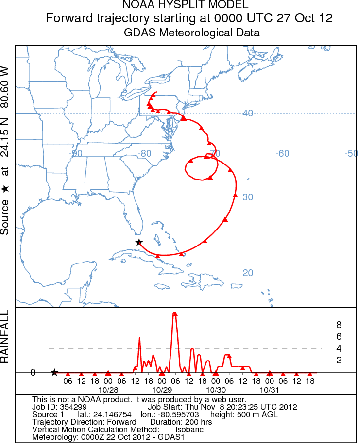
A HYSPLIT model showing the movement of an air parcel originating in the Florida Straits at sunset on 26 October 2012 EDT suggests a plausible explanation for Neotropical migrant birds arriving in the Northeast US on 1-3 November 2012. The trajectory depicted on the map is broken into 6-hour increments, and the scale below the map shows the rainfall totals in the parcel of air at each of these same, 6-hour increment. Note that the time axis is in UTC, so local EDT is UTC-4.
We think that the explanation for this may be straightforward – if our assumption about migrants departing from Florida on the night of 26 October is correct, these birds would have become entrained in the westerlies to the south and west of Sandy’s center of circulation, getting swept out to sea to the east over the Bahamas. These birds would presumably continue in the circulation for at least two days, eventually reaching southerly and easterly winds, wrapping around the east side of the storm system. Once entrained in unfavorable winds over open ocean, it is thought that most birds simply fly downwind to cover as much ground as possible. To the extent possible, the birds may try to avoid areas of heavy precipitation: those that succeed might survive, while those that did not likely perished. Once the strongest unfavorable winds and conditions pass, birds may actively try to reorient and return toward the US coast. In interesting pattern to note: almost all of the out-of-place Neotropical migrants that appeared post-Sandy occurred North of the landfall and subsequent track inland. We suspect that birds that did not remain well east and north of the deteriorating eye (and thus north of the track) probably would have encountered heavy precipitation and been forced into the ocean. The 26-27 October departure time matches well with the discovery of Eastern Wood-Pewee in coastal Massachusetts on 31 October (may have arrived a day or two earlier), Bay-breasted Warbler and Northern Parula nearby on 1 November, and many other out-of-place sightings.
A European Visitor: Northern Lapwing
Perhaps the most amazing twist to the Sandy avian extravaganza was the appearance of at least 11 Northern Lapwings in Newfoundland (1), Nova Scotia (1), Maine (1), Massachusetts (4 at three locations), New York (3 at two locations) and New Jersey (1) since 30 October. Amazingly, this North American set of occurrences is likely related to the passage of Frankenstorm Sandy as well! Furthermore, there is some evidence of a related occurrence of out of range lapwings in the North Atlantic: Northern Lapwing is a vagrant to the Azores, where up to eight were reported between 31 October and 2 November!
Northern Lapwing is not your typical hurricane bird, certainly not in Northeastern North America! Most tropical storms track north and east, so are much more likely to send American birds to Europe than vice versa. In some past years–most notably December 1927 and January 1966–strong easterly winds associated with similar strong high pressure systems over the North Atlantic have resulted in lapwing fallouts (see Alerstam 1990). Necessary conditions include a migration of lapwings over water (usually departing Scandinavia for the United Kingdom or mainland Europe) and strong easterlies that stream across the North Atlantic. In the case of Hurricane Sandy, it was not the tropical system itself that brought the lapwings, but her interaction with high pressure over the North Atlantic that yielded the appropriate “lapwing winds” (and also provided the mechanism for Sandy’s rapid, devastating, but predicted turn to the Northwest and eventually to the New Jersey coast.)
A so-called “rex block” of high pressure over the North Atlantic blocked Sandy’s movement north and east into the open ocean, a track typical of late season storms. This blocking high had major east to west winds associated with it and Sandy’s counterclockwise circulation just accentuated those winds as she moved north. And, if we return to our air parcel modeling, we see that there appears to be a direct connection between the European and North American continents, at least for some air parcels, in conjunction with the rex block! Thus, the timing of air mass movements and their origins seem to offer a clear connection for this species’ occurrence in the Northeast. The timing of arrival of the all the late October – early November 2012 observations differ slightly, and presumably there are several factors that could account for this including different lapwing origins and different paths across the Atlantic. Regardless, it seems not only possible but plausible that Lapwings from Europe were transported to North America, but also to the Azores via this air circulation! Additionally, another Northern Lapwing occurred in Iceland on 13 October, perhaps an indication of larger regional movements underway and a harbinger of the appearances to come in the Northeast US and the Azores.
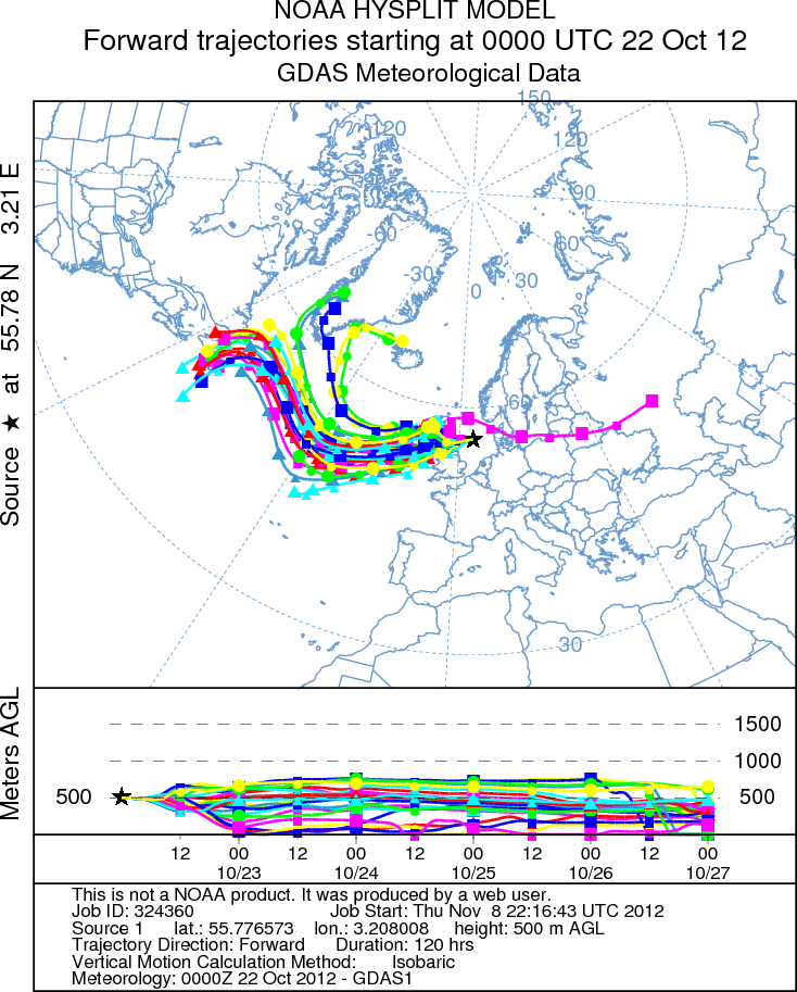
An ensemble of models for the movement of an air parcel 500m above the ground, each component incorporating slight variations in meteorology, creates a spaghetti diagram. As complex as this model might appear, the interpretation is reasonably simple – air parcel originating over the North Sea on 22 October makes it ways west across the North Atlantic into the North American migration system, almost regardless of slight variations.
References
Alerstam, T. 1990. Bird Migration. Cambridge University Press, Cambridge, New York, Melbourne, 420 pp.
This story was written by Andrew Farnsworth, Marshall Iliff, and David Nicosia.