During the past week, enormous numbers of birds have been migrating through the US. A review of our live migration maps, in particular the night of 14-15 May, confirm several nights well above 400 million birds aloft!
These massive flights may not, however, have produced spectacular birding on the ground. When significant meteorological phenomena that normally concentrate migrants (e.g. heavy rain, frontal passages) are absent or more localized, birds spread out more readily over suitable stop-over habitat, and fly for longer distances (e.g. overflying many possible stopover areas). During stable weather conditions birds often take advantage of favorable wind flow and receive a boost from such supporting winds. Supportive winds may occur at very high altitudes (over 3 km / 10,000 feet), and birds have an amazing ability to find these supportive winds in complete darkness, leading to the formation of high-altitude migration layers shortly after sunset (making detection of their presence by monitoring flight calls difficult or impossible)
Although the perception from terrestrial observers may be of few birds present, radar data illustrate a very different pattern of huge numbers of birds aloft over the last few days. The first animation below shows the enormous movement of 14-15 May from the perspective of migration traffic rate (the legend on the right illustrates the rates) and number of birds in flight (the counter in the lower left).
Flight altitudes of these movements varied noticeably across the contiguous US. In the animation immediately below, the scale showing height categories and mean flight height above the ground (in meters) is in the lower left corner. Note that flights over Texas and portions of the southern Mississippi River Valley as well as over portions of the northeastern US and Pacific states occurred at altitudes over 1000m above ground level on average, and in some cases over 1500m above ground level (for reference, the Empire State Building is 381m tall).
Large numbers of birds were on the move on 19-20 May.
High flight altitudes were apparent in some of the same areas as we see in our first example, above, but also in different areas including over portions of the Midwest and northern Great Plains.
Peak flight altitudes are often substantially higher than the mean flight altitude shown in the above visualizations. Below figure shows the flight altitude patterns at a single location in western Pennsylvania (KPBZ radar) for the same night of 19-20 May, with the color scale indicating the density of birds aloft (in birds / cubic km). After sunset, high altitude layers form at 1500 metre and 2500 metre in the beginning of the night. Later in the night flight altitudes gradually decrease as birds prepare to make a stopover on the ground. Complex altitudinal patterns like this were visible above the entire Mid-West and North-East.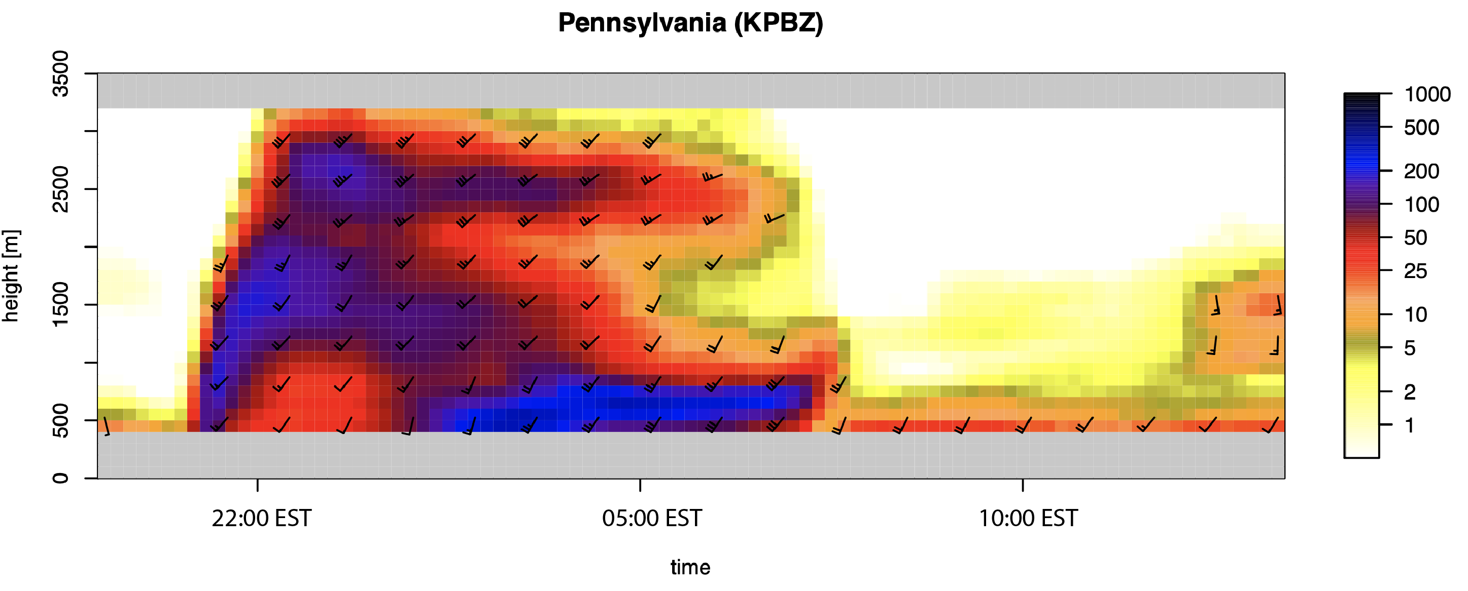
20-21 May saw another large pulse of migration across the country.
Altitudes show a similar distribution as the previous night, but with additional high altitude flights over areas of the eastern Great Lakes.
The species involved in these flights may be diverse, including primarily smaller-bodied songbirds, as well as larger-bodied waterbirds and shorebirds. This recently published study illustrates the exceptional altitudes even small birds can achieve.
We look forward to sharing more explorations of bird movements with new visualizations over the coming year. Stay tuned!