News: Cyclones
Following last week’s post about the North Atlantic Oscillation (NAO) and the promise of European vagrants in North America, we thought it useful to note the current forecast from NWS Climate Prediction Center for the NAO index. The graphic below shows the forecast for the NAO index for the coming two weeks. Note, that there is a […] Read more...
Hurricane Sandy’s epic, devastating, and predicted jog to the Northwest just prior to her New Jersey landfall was driven, largely, by a “rex block” or “Greenland block” – serious high pressure over the North Atlantic that, in effect, blocked the passage of the gigantic circulation of Sandy and forced her inland over New Jersey and Pennsylvania as she worked […] Read more...
The Weather Channel has taken to naming winter storms for the 2012-2013 winter season, and Brutus is at bat. This powerful storm is dumping heavy snow in parts of the Rockies, and the associated frontal boundary strongly demarcates much colder from very warm air. As the low tracks east, strong southerly and southwesterly flow prevails […] Read more...

Hurricane/Post-tropical Cyclone Sandy and all of her fury are firmly ensconced in the record books, and this storm will remain forever in the lexicon of Northeastern US weather lore (probably foremost ahead of the 1938 Long Island Express). This is certainly true from an ornithological perspective, with some avian effects from Sandy still apparent 11 days […] Read more...
Numerous articles linked and referenced the BirdCast website during the extensive media coverage of Hurricane Sandy. The following is a list of links to radio, print, and Internet coverage of the storm relevant to (or referencing) BirdCast. Discovery.com – EXCELLENT IDEA OF THE DAY: POST-SANDY BIRDING NewsDay – Exotic birds traveled to Long Island with Sandy […] Read more...
To follow yesterday’s post, get out a look for landbirds!!!! Something extremely interesting is occurring in the wake of the epic passage of Sandy. Recent reports from Maryland to Maine of a bizarre mix of Neotropical migrants, including Connecticut Warbler (MD), Yellow-billed Cuckoo and Scarlet Tanager (NY), and Eastern Wood-Pewee (MA), suggest that the effects […] Read more...
For those out birding from the mid-Atlantic through New England and west to the Appalachians and the eastern Great Lakes, today was a wild day of birding. Several blogs have captured the ornithological events spawned by Sandy’s arrival onshore, and numerous meteorological sites have detailed the extreme devastation of the storm. As a final component […] Read more...
The remnants of Sandy, huge as they are, have a circulation that has just passed Philadelphia, PA. All of the meteorological forecasters involved in predicting the path of this system did quite an amazing job – now, team eBird and BirdCast will get to see how we did at predicting the ornithological outcome. Tuesday morning […] Read more...
The center of the circulation is mostly ashore near Atlantic City, NJ as of 8PM EDT, the system is now behaving more like a Nor’easter though still with some tropical characteristics, and the effects of Sandy are widespread and dangerous. Record-setting storm surges are occurring, winds of Category 1 hurricane force and gusting to 90-100 […] Read more...
Team eBird has posted an update on Sandy birding strategies here, including species that might be possible. Additionally, please follow live updates posted by our friend Drew Weber here. After many days of speculation, Hurricane Sandy is making landfall in southern NJ later this evening, slated to progress west over Delaware Bay and into western Maryland and […] Read more...
Hurricane Sandy is coming ashore later today, with many areas of the mid-Atlantic and Northeast feeling its widespread and intense effects for some time. Given the present track, similar to previous forecasts, the most likely place for entrained pelagic and Tropical species will be from Delaware Bay north and west into the Delaware River into […] Read more...
The most recent forecast has not changed terribly – this massive storm’s circulation looks to be coming ashore on Monday night along the southern or central New Jersey shore, moving inland to central Pennsylvania by Tuesday night, into Lake Ontario on Wednesday night, and then north and east into the St Lawrence by Thursday night. […] Read more...
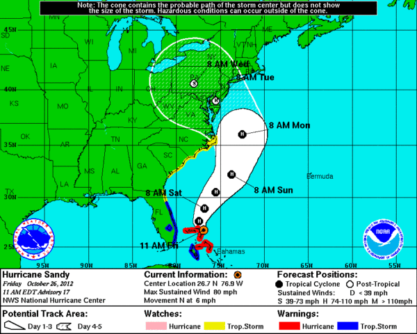
8PM EDT updates to Hurricane Sandy’s forecast track suggest that a late Monday and early Tuesday landfall in central or southern New Jersey is still likely. However, as hinted (and written) in previous forecasts, this storm is huge, and regardless of the exact landfall, many area of the mid-Atlantic and New England will feel the […] Read more...
As Hurricane Sandy approaches, the magnitude of this unprecedented storm is becoming apparent. As stated previously, be extremely careful and cautious if you are in, near, or around this storm, as conditions will be extremely dangerous. Safety first! The present track has changed little from this morning’s update, and presumably a central New Jersey landfall is […] Read more...
Forecasts are likely converging by this point, and a central New Jersey coast strike seems likely. Please see eBird for a discussion of possible species composition of the storm. Landfall is slated to occur very early Tuesday morning on 30 October, and at first light the eye is likely to be somewhere inland in central […] Read more...
The forecast track for Hurricane Sandy has changed, again. Now, the eye is forecast to move farther north, coming ashore at first landfall somewhere north of Cape May, NJ and moving rapidly across the state into central Pennsylvania by Tuesday night, Lake Ontario by Wednesday night, then into Canada by Thursday night. It appears that […] Read more...
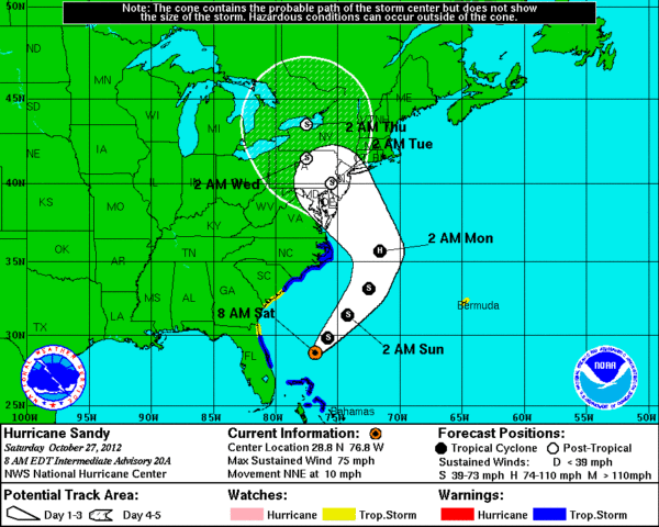
As expected, the forecast track for Sandy has changed since the last update. For more details about the potential “windfall” from Sandy’s arrival and strategies for birding , please visit the eBird site. As of 8AM EDT on 27 October, NHC plots first landfall in the Lewes, DE and Cape May, NJ area in the […] Read more...
Hurricane Sandy is now forecast to make landfall around 7AM on Tuesday morning in the northern DelMarVa peninsula. The storm’s track takes it North and West toward central Pennsylvania and eventually Lake Erie. Birders in Cape May may be extremely well positioned for birds and for dangerous conditions – the northeast quadrant of the storm […] Read more...

Hurricane Sandy is forecast to make landfall along the central New Jersey coast some time during the morning of Tuesday 30 October. This storm is not forecast to maintain consistent, hurricane force winds, but may have intense gusts, will have heavy rain, and may bring large storm surges. The low intensity and track of the […] Read more...
NEWS CATEGORIES
POWERED BY