
Continental Summary This week’s migration forecast highlights the effects of a strong frontal boundary crossing the country, facilitating light and scattered moderate movements with its approach to a region and shutting down migration in its wake. West Generally unfavorable conditions ground most migrants, although scattered light migration will occur in isolated areas with more favorable […] Read more...
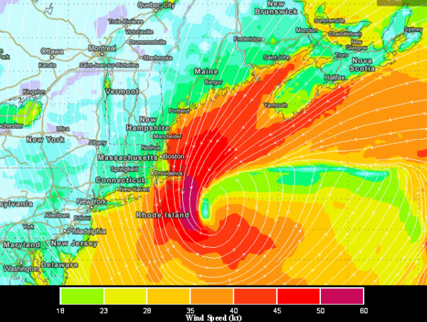
Although we are still quite early in the season to discuss the potential for a “slingshot” event that might cause typically southern spring migrants to overshoot their intended destinations along the Atlantic Coast, and although these events are relatively rare each season, team BirdCast would like to highlight some of the conditions along the Atlantic […] Read more...
Although some portions of the Western US will see light and scattered migration by the middle or end of this week (e.g. the Desert Southwest), this week’s weather is dominated by the passage of Winter Storm Saturn across the Central and Eastern US and mostly unfavorable migration conditions. The animation below shows a morning and […] Read more...
Enter the lion! A potentially substantial winter storm is brewing, Saturn, and forecasts suggest it will leave its mark across a wide swath of the northern US. We focus on the NE US in this post, because of the continuing thread of Eastern Promises and the potential effects for birds from any Nor’easter. The animation […] Read more...
As hinted in last week’s post, there was some potential for scattered light migration across portions of the South-Central and Southeastern US. On 19 February 2013, as a substantial frontal boundary approached the Mississippi River valley, conditions for nocturnal bird migration were favorable in many areas of the eastern Gulf Coast east through the Carolinas. […] Read more...
In our last post, we highlighted an area of southerly flow that is forecast for Sunday – Tuesday, 17-19 February 2013, from portions of Texas to the western Appalachians. Below, we provide a short animated clips to show the forecast wind and precipitation for the coming week, highlighting the early week period in the South […] Read more...
Two interesting patterns may spice up the mid-February birding scene next week. High pressure building into the Southeastern US should bring a period of warmer, southerly flow to many areas of the Gulf Coast by Monday. These conditions may facilitate some typically early migrant songbirds and waterfowl to move on Monday night. Radar reflectivity values […] Read more...
If the groundhog were a birder, perhaps he would have predicted six more weeks of a winter like this . . . We know that Punxsutawney Phil did not see his shadow. Many in the US probably rejoice at his early spring prediction, but, with a winter like this, many birders may not be so thrilled […] Read more...
January in the temperate Northern Hemisphere is not typically a time that most consider as falling within “spring migration.” Rather, local and facultative movements of wintering birds and irruptive movements tend to dominate birding discussions, observations, and field trips. However, here we are on 1 February talking about the arrivals of the earliest migrants in the […] Read more...
So far, the negative NAO index that team BirdCast pondered late last year has yet to materialize with the strength of the October-November period. However, recent weather in Europe and some forecasts for the short term suggest the potential for facultative bird movements to occur. The Meteoalarm website paints a picture of cold temperatures and […] Read more...
Well, the Fieldfare you so desired for the holidays certainly may have been beneath whatever vegetation is part of your holiday celebrations, but not if you live in North America. Although a number of Black-headed Gulls and Tufted Ducks are present, along with a suite of Barnacle Geese, presumably little action occurred in what turned […] Read more...
The National Operational Hydrologic Remote Sensing Center produces national snow analysis graphics. As of 28 December, as seen in the graphic below, approximately 64% of the United States is covered in snow! This is a dramatic change from the previous week, when 20% less of the country was covered in snow. Such extensive cover may translate into […] Read more...
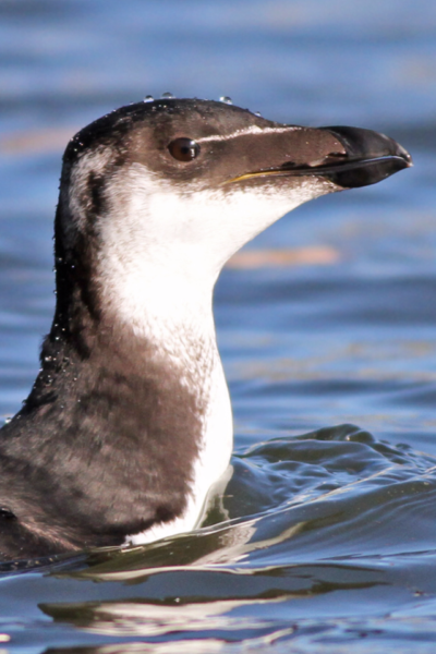
As if this year did not already have enough displacement, entrainment, diversion, and irruption, along comes the Razorbill flight of 2012. Early December saw an unprecedented invasion of this species, which normally winters almost exclusively north of the mid-Atlantic states, into the waters off of Florida, with some individuals rounding Cape Sable and appearing in […] Read more...
Following last week’s post about the North Atlantic Oscillation (NAO) and the promise of European vagrants in North America, we thought it useful to note the current forecast from NWS Climate Prediction Center for the NAO index. The graphic below shows the forecast for the NAO index for the coming two weeks. Note, that there is a […] Read more...
Hurricane Sandy’s epic, devastating, and predicted jog to the Northwest just prior to her New Jersey landfall was driven, largely, by a “rex block” or “Greenland block” – serious high pressure over the North Atlantic that, in effect, blocked the passage of the gigantic circulation of Sandy and forced her inland over New Jersey and Pennsylvania as she worked […] Read more...
BirdCast was referenced in the New York Times in the Tuesday Science Times on 13 November 2012 in the story, “To Birds, Storm Survival Is Only Natural,” by Natalie Angier. Additionally, BirdCast PI Andrew Farnsworth was quoted in this article. Read more...
“Hindcasting” is something of great interest to team BirdCast, particularly as a means of improving (eventually) our modeling and thinking about where, when, and how birds appear when and where they do. In this case, let’s look at what happened in the southern Great Plains on Sunday night and Monday morning, 11 and 12 November, […] Read more...
The Weather Channel has taken to naming winter storms for the 2012-2013 winter season, and Brutus is at bat. This powerful storm is dumping heavy snow in parts of the Rockies, and the associated frontal boundary strongly demarcates much colder from very warm air. As the low tracks east, strong southerly and southwesterly flow prevails […] Read more...

Hurricane/Post-tropical Cyclone Sandy and all of her fury are firmly ensconced in the record books, and this storm will remain forever in the lexicon of Northeastern US weather lore (probably foremost ahead of the 1938 Long Island Express). This is certainly true from an ornithological perspective, with some avian effects from Sandy still apparent 11 days […] Read more...
Today through Friday has potential to see winds transport waterfowl, gulls, and other late migrants and irruptives into the Northeast and Great Lakes. Additionally, snow cover may force sparrows and open-area species like pipits, longspurs, Snow Buntings, and larks to move from areas where more than 1-2 inches covers the ground. Please make sure to […] Read more...
NEWS CATEGORIES
POWERED BY