News: Migration
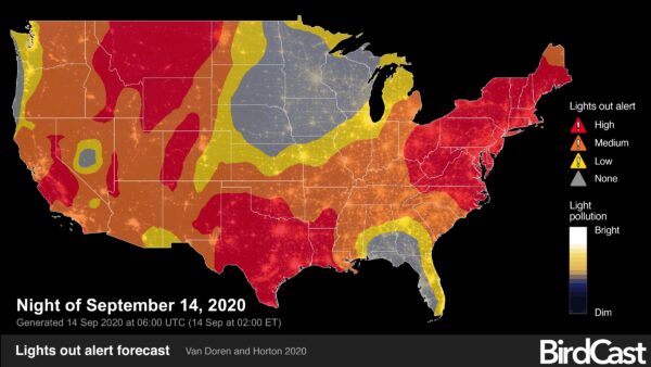
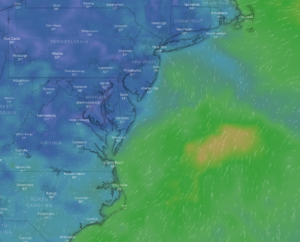
The BirdCast model is predicting high intensity migration for the night of 14 September 2020. We estimate that 405 million birds will take flight tonight across the lower 48, including 50 million birds in the northeast alone. This will likely represent one of the largest migration nights of the year in this region. Read more...
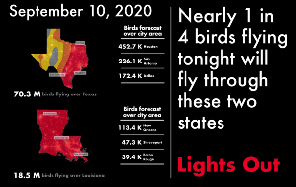
The BirdCast forecast model is predicting high intensity migration this evening, and we estimate this migration will comprise more than 400 million birds. The highest intensity movements will occur in Texas and portions of the southern Appalachians and lower Mississippi River valley. Read more...
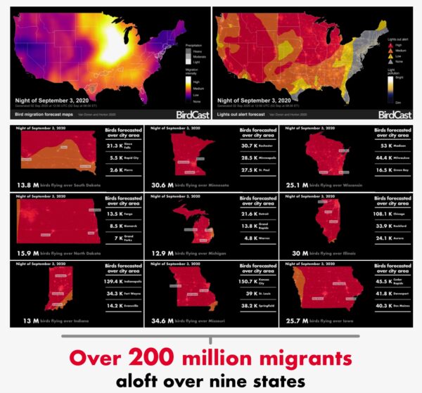
More than 200 million migrants will be aloft this evening over the US. These massive movements present some unique opportunities to experience bird migration and act to protect birds by turning off lights at night! Read more...

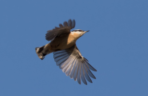
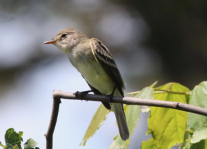
You've recently watched a small flock of songbirds fly over while watching an autumn morning's migration unfold, perhaps hearing a sharp "tick, tick... tick, tick" even before seeing the birds. Congratulations, you've seen a Purple Finch, this week's species on the move. Read more...
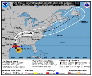
Laura is or will soon intensify to a Major Hurricane with unsurvivable storm surge and extremely dangerous conditions. Current forecasts predict landfall near the Texas-Louisiana border. Avian impacts from Laura's landfall north to Arkansas and east through western Tennessee are likely on Thursday and Friday. Read more...
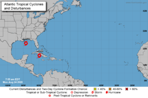
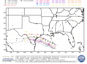
This week the Gulf Coast of the US will experience landfall of two tropical systems, Laura and Marco. This dangerous twin bill will come with flooding, storm surge, heavy rains, and wind in many areas of the western Gulf of Mexico and lower Mississippi River valley. BirdCast is tracking the arrival of the two storms, and you can monitor with us on two maps tracking bird observations as they occur with landfall. Read more...
Team BirdCast like many other groups is watching the progress of three tropical systems that may make landfall in the US next week. Stay tuned for updates in the coming days! Read more...
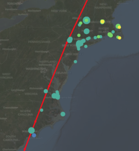
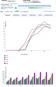
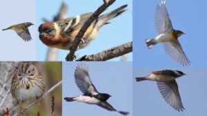
Could recent August observations of Red-breasted Nuthatch in coastal New York represent the beginning of another strong southbound flight of the species this autumn and winter? Read on to consider patterns, correlations, and ways you can help us understand these movements by submitting your observations! Read more...
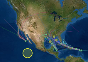
Sooty Tern is often the bird of tropical weather systems once ashore (or very close to shore). Numerous records of far-flung individuals pepper the archives of such weather systems, and Hurricane/Tropical Storm Isaias was no exception. Read more...

Hurricane Isaias is forecast to make landfall in the US on the Carolina coast after grazing the Florida Peninsula and passing directly over the Bahamas and nearby islands. This storm will likely produce hazardous conditions where it passes, including damaging winds, dangerous storm surges, and torrential rains with flooding, and it will bring seabirds and other entrained and displaced species ashore far afield from their typical locations. Check out our live sightings map at the end of the post; and follow updates as we make them. Read more...
A tropical system is building in the Gulf of Mexico, forecast to intensify in the coming days and then move ashore in central or southern Texas. Whether this system intensifies to hurricane strength or continues as a tropical storm or depression, it is likely to bring an array of seabirds ashore in southern and central Texas and possibly northern Mexico. Read more...
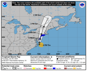
Tropical Storm Fay is a fast moving system that is forecast to travel a similar path to Hurricane Irene at a similar time as Tropical Storm Bertha. What will this system hold for those that can observe safely in the DelMarVa, coastal New Jersey and Long Island, Hudson River Valley, Lake Champlain, and St. Lawrence RIver Valley areas? Read more...
Final Spring 2020 forecast and live migration maps tonight (and some closing thoughts on the season)
As of June 9-10 Team BirdCast is calling spring 2020 a wrap. Our forecasts and live migration maps return on or about 10 August 2020. In the coming months we hope to follow several threads from stories we highlighted during the spring. Here are some possibilities. Read more...
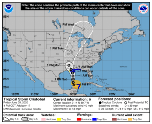
Here comes Tropical Storm Cristobal, forecast to make landfall in southeastern Louisiana on Sunday evening. With safety the top priority, we briefly highlight a few possible tropical and pelagic species that might appear far inland in the wake of the storm's passage. Read more...
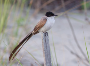
We are nearing a seasonal window during which many records of Fork-tailed Flycatcher, a spectacular and elegant vagrant to the US from South America, have occurred. The BirdCast team thought you might like to know that conditions could be favorable for the arrival of this wandering species somewhere in the US ... maybe. Read more...
23 May 2020 on the eastern shore of Virginia brought some migration magic to a small habitat patch for some lucky observers. Just over 200 migrants in a 10-acre patch. Our friend Ned Brinkley describes the action and puts it in proper perspective. Read more...
A stationary front in the Carolinas, evolving into a cold front and moving offshore with some strong storms and southerly flow in advance of its movement, could make for some interesting birding along the immediate mid Atlantic and Long Island coasts. Read more...
A massive migration event occurred on the Massachusetts coast on the morning of 16 May 2020. Several observers were fortunate to be on the ground in the right place and the right time. Here's the story! Read more...

The passage of an unusually intense late May cold front will result in strong northwest winds along the Pacific Coast through the weekend and could bring pelagic goodies to shore. Read more...

Spring 2020 has seen some anomalously low temperatures in the northeastern US, and no exception is the coolest May going back to the 1990s. But changes are coming this weekend. Read more...
NEWS CATEGORIES
POWERED BY